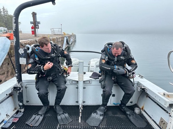
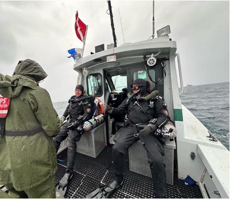
Situated on Lake Superior’s northern border with Canada and only accessible by either ferry or seaplane, you can’t haphazardly add a stop along your route to visit Isle Royale. The 45-mile-long island designated as a wilderness area is home to over 160 miles of trails in which only moose, wolves, and few hikers roam, without a single car in sight. Most commonly, backpackers prepare for the 4-5 day traverse from Rock-Harbor to Windigo on either end of the Island connected by the 40-mile-long Greenstone Ridge Trail. It’s safe to say far fewer visitors come to dive the many shipwrecks scattered around the island, as Lake Superior’s waters consistently hover around 40 degrees even in summer months. Given that I’ve only recently been introduced to diving in a drysuit and am a newly minted rebreather diver, I won’t be joining the SRC below the surface on a working dive quite yet, but I am looking forward to seeing the SeaArray system in operation and providing topside support.
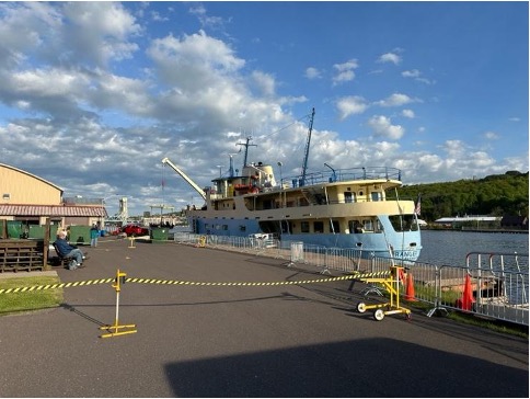
I leave Miami so early in the morning I feel that I might still be dreaming. Finally, the much-anticipated long day of travel is here. Aside from a few emails and phone calls, I still have yet to meet anyone from the SRC team. It was at a short layover in Chicago that I met Brett Seymour, SRC Deputy Chief and Audiovisual Production Specialist, for the first time. From there, we board a smaller plane heading into Houghton, Michigan where we would then catch the Ranger III ferry the following day to get to Isle Royale. It’s always a great sign of what’s to come when you trade bigger planes for smaller planes. Once we arrive in Houghton, we head to the dock to greet AJ, an Archaeologist with the SRC who is heading back from Isle Royale after assisting the park with buoy maintenance. We load up the coolers and head to the grocery store to tackle my most dreaded task; stock up on all the food I could possibly need for the next week on the island. A few panic buys and countless extra aisle pass-throughs later, and I manage to fill up a cooler that I am confident will last me at least a week.
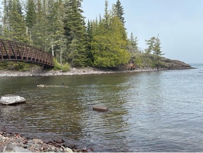
The next morning, we pick up David Morgan, a Senior Archaeologist with the SRC, who flew in straight from a family vacation in Mexico to join Brett in diving and gain cold water dive experience (talk about a temperature difference). Once all our bags and coolers make it onto the Ranger III, we board and do a lap around the ship to get accustomed to its Wes Anderson-esque design and the many seating options it has to offer for our six-hour journey to Mott Island — home for the next week. Jim Nimz, SRC Dive Operations Specialist, is already on Mott Island after completing various National Maintenance Dive Team tasks the week prior. We spend the evening settling into our dorms, unpacking our food, and becoming acquainted with our surroundings. Because the sun only sets around 9:30 PM, I’m able to squeeze in an evening hike to get to see some of the park’s gorgeous scenery and rocky shores.
Seth DePasqual, the Cultural Resource Manager at Isle Royale, joins us each morning to discuss our field plans, the park’s priorities, and how SRC can help achieve them. Most of our days over the next week will be spent at the Glenlyon shipwreck, a 328-foot freighter powered by a triple expansion steam engine that sunk after striking the reef during a storm in 1924. The stern and bow sections sit to either side of a shallow relief fittingly named Glenlyon shoal, where the freighter initially ran aground and split in two. Due to the size of the site and the depth range from one section to the other it typically requires at least three imaging dives to piece together the entire wreck — stern, bow, and shoal in the center connecting the two.
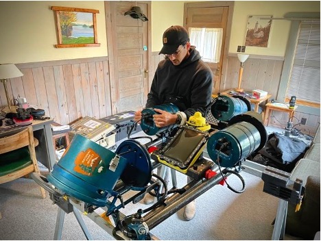
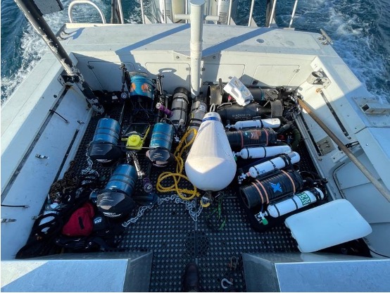
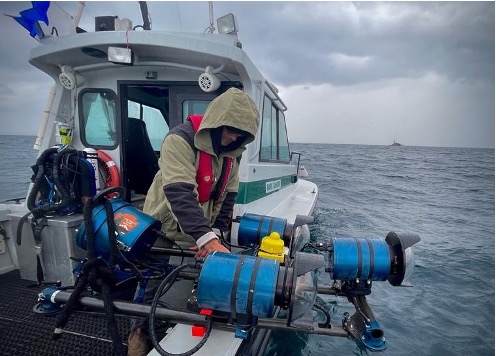
Preparing the SeaArray system for the long days ahead, I’m fortunate to go through the setup piece-by-piece with Brett. He has meticulously developed and refined the system over the past four years alongside Evan Kovacs from Marine Imaging Technologies. Each component of the camera array is uniquely selected for ease of use in harsh field conditions, where divers are commonly wearing dry suits, gloves, and thick undergarments greatly limiting their dexterity and mobility. There is a fine balance throughout the system — components need to be robust enough to deal with the wear and tear of extensive field operation yet be replaceable and interchangeable if damaged. Maintaining a modular design, its arms can be folded in, letting it fit through dive doors and limit its footprint on valuable deck space while aboard the Cal Cummings (SRC’s Vessel). In combination with UWIS (a subsea positioning system), real-time location can be relayed to the diver on an underwater iPad, assisting with navigation across big sites and revealing track lines to show coverage and areas that may need more passes.
Throughout the week, I start each day with a hike on Mott Island, exploring trails, encountering moose, and enjoying the island’s gloomy weather. It’s no surprise many ships have run aground on the surrounding shoals; fog and weather can roll in quickly, reducing visibility to near zero. Depths can drop to just a few feet even miles off the coast. The island’s lighthouses often appear and disappear in the fog, evoking the eerie experience of those who were once on the now-sunken ships. Given the unpredictable conditions of Lake Superior, we maintain constant radio communication to ensure safety, relaying position, status, and ETAs with dispatch centers via the island’s radio repeaters.
Between our daily trips to the Glenlyon, we take a day of long motoring to Windigo, where the SS America, a 182-foot freighter that ran aground in 1928, lies at the entrance of Washington Harbor. This ship is largely intact and sits with its bow in only four feet of water, while the stern reaches approximately eighty feet. The large variation in depth makes imaging difficult as it greatly impacts buoyancy and available light. While I’m not typically used to being on the boat while others are diving, the unforgiving nature and challenge of diving in Lake Superior is not a place to be trying multiple new things out all at once. However, the allure of diving in such a challenging environment is something I am determined to take part in in the future. Funny enough, I can still say I managed to take a dunk in Lake Superior. My overcommitment to hook a subsurface buoy while not hooking my leg on the gunnel taught me a valuable lesson. And yes it’s cold…very cold.
With a week’s worth of imagery collected, every evening is spent combing through images, running preliminary alignments, ensuring backups, and preparing SeaArray for another long field day. Having the ability to process data in the field is not a luxury I am accustomed to, and having portable computers that are powerful enough to run models throughout the night is an incredible asset. Talking through various processing methodologies and data organization surrounds the background of most of our nights, as the desire to streamline and perfect any workflow is always constant and never-ending.
Our last days at Isle Royale are spent repacking the numerous Pelican cases of equipment like tetris into the trailer that will be loaded back onto the Ranger III and towed with us to Denver. We get to meet with the park’s superintendent, Denice Swanke, with whom the SRC summarizes what it has accomplished, what work remains, and future goals. It is apparent that the SRC is first and foremost at the service of the park it is visiting, keeping the park’s priorities at the forefront while managing to accomplish imaging in conjunction with other tasks. Once the crane on the Ranger III picks the loaded trailer up to its deck, the long road back to Denver begins: a day and a half of continuous driving with a short pit stop just outside Minneapolis. David Morgan and I take turns driving behind Jim and Brett who are towing back the Cal Cummings. On the home stretch, one of the trailer tires blows out as though just to keep us on our toes.
Once in Denver, the unpacking begins, or rather the repacking. Dave, Brett, and Jim are headed to Alaska in a few days and much of the equipment coming out of the trailer will be organized in a pile to head there with them. Dave Conlin, SRC Chief, shows me around the new dive locker, a massive area where things are currently staged as they are being moved from the old headquarters. Building shelves, organizing equipment, and making sense of what belongs where keeps everyone busy over the next few days.
This trip has given me a glimpse of the operating tempo and caliber of work the SRC provides the NPS, and I am extremely grateful to have the opportunity to work alongside the team on more trips this upcoming summer. Stay tuned for my next blog from an expedition to a shipwreck you just might have heard about – RMS Titanic.

Enjoyed ready your blog. Where can I find mire info on SRT?