Category Archives: 2011 National Park Service

Washington DC and the End of this Big Adventure (which is really the beginning of the next one…)

My last stop this summer took me to Washington DC to culminate my internship by experiencing the National Park Service (NPS) from the standpoint of national policy-making. I left Woods Hole Oceanographic Institution (WHOI) one week into my new job for a visit to the big city–excited and nervous to spend 5 days in our nation’s capital. I visited DC once before, for a few days of intense museum-going. On this trip, my days would be filled with meetings at NPS headquarters, National Geographic, and the Smithsonian. It doesn’t get any better!

I arrived to absolutely fantastic weather in DC. After settling in to my hotel, I took the afternoon to re-visit my favorite museum in the city, the Smithsonian National Museum of Natural History (of course) and take a walk along the National Mall. As evening fell, I took some night shots at the Washington Monument and National WWII Memorial. Unfortunately the Reflecting Pool was closed for reconstruction, so I couldn’t photograph that iconic view towards the Lincoln Memorial. The Washington Monument was still closed due to damages from the earthquake earlier in the year too, but it and all the other monuments along the National Mall were quite impressive flooded with light at night and made for fun photographing.

The next day, I headed to National Geographic to meet with photo editor Todd James who graciously agreed to meet with me and show me around. First we headed down to the engineering department to see some of the innovative ways that engineers and photographers team up to capture previously impossible images using new technology. After a tour of Nat Geo’s buildings and a look through the new photography exhibit by Brian Skerry, one of my favorite underwater photographers (the exhibit is called Ocean Soul, I highly recommend it if you are in the area: http://events.nationalgeographic.com/events/exhibits/2011/10/05/ocean-soul/), we went back to Todd’s office where he gave me an inside look at his job as a photo editor for the magazine. From project proposals, to research, to sorting through tens of thousands of images, the job of a photo editor requires a diverse knowledge base and an aesthetic eye. I gained a much greater appreciation for the process through which photos end up on the pages of National Geographic. Like every other photographer, I dream of having my own images printed in this magazine someday, so it was extremely valuable to gain an inside perspective of the process. Todd was so generous with his time and answered all my questions with patience. Additionally, he was kind enough to review some of my images from this summer and offered some very encouraging and helpful advice for my portfolio development.

The following day was my big debut at NPS headquarters. I met up with Cliff McCreedy, Marine Resource Management Specialist in the Ocean and Coastal Resources Branch of the Water Resources Division. Cliff had scheduled a meeting for us at the Department of the Interior (DOI), but first, we set up a presentation I made for a lunchtime talk in one of the conference rooms, where I met Jonathan Putnam, International Cooperation Specialist for the NPS Office of International Affairs (http://www.nps.gov/oia/). Did you know that the NPS participates in international collaborations to aid in the creation and management of national parks around the world? I didn’t, but it just makes NPS that much more amazing to me!

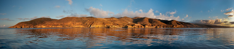
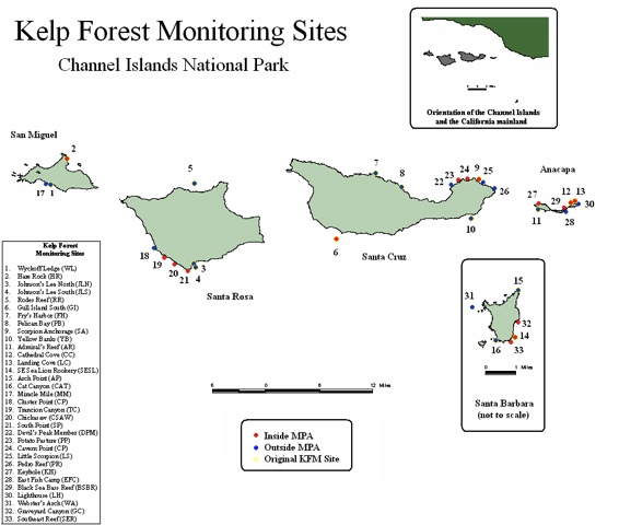
Before we headed to the DOI, Cliff gave me an overview of the recent history of marine and aquatic natural resource management in the NPS. While active management of our marine and coastal resources has always been an official part of the National Park Service’s mandate, it was not until in the mid-2000s when increased management concerns led to the creation of a specific branch of the NPS dedicated solely to this purpose in the arena of marine and coastal natural resources. Much of the credit for establishing the Ocean and Coastal Resources Branch can be given to Gary Davis, who was instrumental in the formation of the Kelp Forest Monitoring Program at Channel Islands National Park. A marine ecologist, Gary understood the importance of establishing baseline knowledge of the ecological communities within the submerged lands of our parks, and long-term monitoring to study the health of these communities, and designed the national ocean program around those two foci.

Cliff and I headed to the DOI, a big, intimidating, granite building, and met up with Dr. Marcy Rockman, Climate Change Adaptation Coordinator for Cultural Resources, who would join us for this meeting. We went inside and met up with Dr. Stephanie Toothman, Associate Director for Cultural Resources, and Julia Washburn, Associate Director for Interpretation and Education, and all three women introduced themselves and their roles within the NPS. I can’t tell you how inspiring it was to meet these three incredibly successful and influential women who are working for the common good, really applying their talents, experience, and education towards a cause that is beneficial to everyone—preserving our heritage.

I shared my experiences from this summer, and discussed all of the incredible work being done by dive teams in the parks I visited. After the meeting, we quickly left the DOI and returned to NPS headquarters, and walked right in to a nearly full conference room! By the time everyone came in and got settled, there were at least 15 people from all different branches of the NPS (Interpretation, Cultural Resources, Natural Resources, Dive Safety, International Affairs, etc.) who had come to hear me share my experience this summer. I had put together a presentation with lots of photos, and talked about my personal highlights as well as the important conservation and preservation stories I learned in each of the parks, like the uphill battle against lionfish invasion in south Florida, or the incredible success of the Kelp Forest Monitoring Program in the Channel Islands. My audience was great, and I was so happy to meet several of them personally afterwards.

We had a chance to meet briefly with Beth Johnson, Deputy Associate Director for Natural Resource Stewardship and Science, as well. She was so friendly and heavily encouraged me to pursue work within the NPS – although it is not really something I need to be convinced of, I would be thrilled to work with NPS! I will be scanning the pages of usajobs.gov religiously from now on, that’s for sure!

The following day I had the chance to meet up with Anya Watson, 2005 Our World-Underwater Scholarship Society North American Rolex Scholar. She is currently working as a Dive Officer for the Smithsonian Scientific Diving Program, which coordinates staff divers in Smithsonian research and education projects around the world. She gave me a tour of the new Sant Ocean Hall at the National Museum of Natural History, and then we went to the National Museum of American History where we perused some of the maritime history exhibits and Anya showed me some of her favorites in the museum’s collection. She also showed me the dive locker, which is oddly enough on a lower level surrounded by paleontological specimens, like dinosaur bones!

Thank you so much to everyone who was so generous with their time this week—Todd James, Cliff McCreedy, Jonathan Putnam, Stephanie Toothman , Julia Washburn, Marcy Rockman, Beth Johnson, and Anya Watson, and everyone who took time out of their busy day to attend my lunchtime talk at the National Park Service!

After three months, I can’t believe my internship is ending. I already can see that this opportunity has irrevocably changed my life; and I am so excited to see how it all plays out. When I first decided to leave Mexico, I had no idea what lay ahead, if I would be able to find a job, apprehensive that I might end up somewhere I didn’t want to be, doing something I didn’t love. Thankfully, the opposite of that is true—this internship directly led me to my new job at WHOI, and a new life (at least for the next few months) in a place I love. I am so thankful to have reacquainted myself with the United States and explored so many potential new homes for the future, and to have created a network of friends and professional contacts on both coasts.

As I have known since the beginning of this internship, while the resources that the NPS works so hard to preserve are irreplaceable and wondrous, the true gem is the group of people tasked with protecting the future of these precious sites and resources. We have entrusted them with our heritage, and they work harder than any other group of people I have ever known to make the American people proud of that heritage. I am beyond proud to have worked with the National Park Service, and hope to continue to working with NPS in the future—I still have so much to learn, experience, and contribute in our National Parks!

Share

Making Connections in My Own Backyard: meeting some professionals of the underwater world making a difference in Northern California

I came home to the Bay Area for a week after the Kelp Forest Monitoring Cruise in Channel Islands National Park, to prepare for what I thought would be my next adventure in Lake Mead National Recreation Area (more on that later). During my week at home, I was fortunate enough to connect with Sara Shoemaker Lind, the Our World-Underwater Scholarship Society (OWUSS) 1997 Rolex Scholar, and Abi Smigel Mullens, OWUSS 2001 Scuba Diving magazine Intern, who are both underwater photographers based in San Francisco. Sara and I couldn’t find a time to connect in person, but we had a great phone conversation during which I received a lot of valuable career advice. She also put me in touch with another former OWUSS Rolex Scholar, Anya Watson, who is currently based in Washington DC, where I would finish my internship. I was able to meet Abi up in San Francisco and speak with her about pursuing a career in underwater photography, and how she balances her field schedule and local photography business. Thank you so much to both Sara and Abi—it is so inspiring to meet other female photographers who are so successful and happy after going through the Our World-Underwater programs.

If you are interested in seeing the work of these two talented women, check out their websites at http://www.sarashoemakerlind.com and http://www.abigailsmigel.com/

I was also able to go to Monterey and take a tour of Light & Motion (an underwater camera housing company) with CEO, Daniel Emerson. Their facility is right on the water in downtown Monterey on Cannery Row (in an old cannery, of course). As I entered, I examined the examples of their housings from throughout the history of the company (which was actually co-founded by OWUSS 1987 Rolex Scholar Michael Topolovac). I found the entire staff to be extremely friendly and welcoming, and I was really impressed by the level of in-house innovation and productivity. Daniel gave me a tour around the building and showed me their range of products, which not only includes their awesome video camera housings but a wide array of underwater and bicycle lights. The new designs he showed me make me so excited for the day when I will invest in my own underwater setup. Their team of engineers is constantly striving to make smaller, more powerful, efficient, and intuitive products. Every step of the process, from design, to engineering models, to fabrication, to packaging, happens at their base in Monterey. As a marine conservation student, I had never seen processes like plastic injection molding and the printing of 3D models before, so all the technical aspects were really interesting to me. I was especially impressed by all the environmental considerations taken in the production of their products. Recycling, minimizing chemical and plastic use, and energy efficient lighting were just a few of the many clear indicators I saw of their environmental commitment. They have actually won several awards for their green business practices (you can find more info on that and their products at http://www.lightandmotion.com/).

It was a fascinating morning, and I can’t thank everyone at Light and Motion enough for being so friendly and generous with their time!

It is always nice to get to know people in your own backyard who have similar backgrounds and interests—this week was a great introduction to the incredible people and companies that call northern California home. This is definitely one of the most unique and wonderful aspects about the OWUSS programs—going through a scholarship or internship provides a lifelong web of people and resources that can guide you on your way to success in the underwater fields (topside too, for that matter!). In fact, I received a call later in the week from Woods Hole’s Advanced Imaging and Visualization Laboratory (http://www.whoi.edu/aivl/), which as you may recall collaborates with NPS Submerged Resources Center for 3D filming of resources in the park system. After I met them working with Brett Seymour in Hawaii, they needed some extra help on a project and called to see if I could come out to Massachusetts ASAP. What an unexpected curve ball! After discussions with my coordinators at NPS, we all decided that working at Woods Hole was an opportunity not to be missed, especially at this lab where my passions of imaging and science are one in the same. In the end I didn’t make it to Lake Mead National Recreation Area, but I still ended up going to Washington DC to wrap up my internship and see the role of NPS on the national level, so be on the lookout for that last blog, coming soon!

Share

Channel Islands National Park

The Channel Islands. This is where I learned to love the oceans as a child. I spent a couple of summers at a marine science camp on Catalina Island, and my days were filled with snorkeling, kayaking, and classes about marine natural history. Those formative summers set me on the path to where I am today. Being back here fills me with a sense of coming full circle. In addition, these islands bear a striking resemblance to the Midriff Islands in the Gulf of California, where I spent my last few years prior to this internship, so it feels doubly like coming home.

A beautiful golden sunrise in the Channel Islands.

Channel Islands National Park consists of five islands, Anacapa, Santa Cruz, Santa Rosa, San Miguel and Santa Barbara, and their surrounding waters off the coast of southern California. The park’s area is split fairly evenly between terrestrial and aquatic environments, and encompasses ~ 250,000 acres. The islands are world-renowned for their endemic species and high productivity. The marine environment is home to some of the best diving in California, with kelp forests that help support the regional populations of fish, invertebrates, seabirds, and marine mammals.

I drove down to Ventura a few Sundays ago to meet Josh Sprague, NPS biological technician, and Dave Osorio, associate biologist for CA Department of Fish and Game, on Sea Ranger II, one of the three boats run by the park. After loading up my gear and getting a good night’s sleep, I woke up on Monday morning to meet the rest of the team as they loaded up on the boat. I met the captain, Keith Duran, and David Kushner, the marine biologist in charge of the Kelp Forest Monitoring Program, who gave me a rundown of the ongoing monitoring run by his team. The other monitoring team members included NPS biological technicians Kelly Moore, Eric Mooney, and Sonia Ibarra, and Student Conservation Association Interns Sarah Traiger and James Grunden.

We set a course for Santa Rosa Island, and spent several hours making the bumpy crossing. I have been fairly lucky this summer with conditions out on the water, and this was definitely my first foray into the Pacific in many years. I was not used to the long period swell of the open ocean!

A map of the new Kelp Forest Monitoring sites.

After battling with mild feelings of seasickness (and continually telling myself “I don’t get seasick), we arrived at our destination. I had been having some trouble with my ears so I decided to take at least today off of diving, but I was so sad about that decision after seeing the conditions out here, which were particularly good for this island. Aside from some current and mild swell, it was beautiful! I stayed onboard as shore support, and at least could enjoy the gorgeous scenery of the island and open-ocean. When the divers came up, I assisted with data recording before we motored to another spot. As the divers were down, I watched and listened to the elephant seals playing in the surf.

The crew of the Kelp Forest Monitoring Program (KFMP) comes out to the islands for five-day research cruises every other week during their summer season, May through October. This project is part of the Inventory and Monitoring (I&M) Program of the NPS, which collects natural resource data to inform park management, and is the force behind the natural resource monitoring projects. I helped with this in other parks this summer like benthic habitat monitoring in Biscayne and water quality monitoring in Crater Lake. Channel Islands National Park was one of the first parks to pilot the I&M Program in 1982, with the KFMP surveying 16 sites within the park. Eight years ago additional federal funding implemented the I&M Program on a national level, based on the successes seen in the pilot parks. Now there are 32 regional networks and more than 300 parks within the program. To date, the baseline data collected from Channel Islands National Park has resulted in the largest continuous data set within the NPS system and has been used for important resource management decisions. While the California department of Fish and Game funds research, they do not fund ongoing monitoring such as the now 30 year KFMP, so NPS data is especially valuable for determining long-term, fisheries independent trends. Even though the park provides monitoring data to the state, NPS has no jurisdiction over living resources, so it is up to the state to create sound policy based on the monitoring data and other factors. Success stories here include the use of park data to support the closure of the southern California abalone fishery after decades of over-exploitation and declines due to El Niño and disease, and implement the state’s first network of marine protected areas (MPAs). For more information about the Inventory and Monitoring Program, click here: http://science.nature.nps.gov/im/index.cfm. For more info about the Kelp Forest Monitoring Program, click here: http://science.nature.nps.gov/im/units/medn/reports/docs/resourcebriefs/MEDN_ResourceBrief_KelpForest.pdf

One of the conservation tactics enacted by the state was the establishment of 11 no-take marine reserves and two limited-take reserves within the park and its adjacent waters (which are also within a National Marine Sanctuary), after the original reserve in the park, at Anacapa Island (est. 1978), first demonstrated that preserving non-fished areas actually increased ecosystem health. The Kelp Forest Monitoring Program continues to collect data to track important long-term trends in species abundance, community composition, and other indicators of ecosystem health at 33 sites in the park, sampling over 70 marine species. A new website, http://pyrifera.marinemap.org/ , allows the public and other resource managers to view data and video transects from the past 30 years of marine monitoring at the park. Check it out!

Diving in Channel Islands National Park

The first site I dove was Trancion Canyon, at Santa Rosa Island, which was at one time in the not too distant past a dense kelp forest. While the dive was beautiful, there were only five small kelp plants in the entire plot area! Urchins have ravaged the site of its herbivorous majority. Nevertheless, there were still loads of invertibrates covering the rocks, and lots of big fish to be seen, including numerous cabezon and lingcod. This dive team tackles numerous objectives on their monitoring dives—about 10 different methodologies to monitor everything from abundance to sex composition of dozens of indicator species. There are divers laying out tapes, setting up quadrates, doing roving fish counts, measuring invertebrates, characterizing substrate, collecting samples for genetic studies, and more. They definitely have the most varied set of tasks of any of the dive teams I have worked with.


After our monitoring dives were over, Sarah and I took an opportunity to hunt for photos. Now THIS is what I call California diving! Towering kelp and tons of curious fish greeted us as we splashed in. I am fairly sure that I saw more big fish on this dive then in all the other dives I had done to date this summer, combined! They were everywhere! Lingcod, cabezon, rockfish—they abounded, unafraid of my big camera coming within inches of their faces. The kelp was healthy and thick. This site is just outside one of the marine reserves, and it shows. The theory behind reserves is that they not only protect critical habitat, but the spillover from these protected areas increases the health of the surrounding areas as well. All I could think about underwater though was how much I had missed being in these underwater forests!


For the rest of the week I dove with the KFMP group at San Miguel, Santa Rosa, Santa Cruz, and Anacapa. Conditions were challenging, with low visibility, strong surge and surface currents, but the team still managed to collect a lot of data and I even managed to get some good images. I am so glad that I learned to use the camera in the calm, clear waters of Florida—I would have been completely overwhelmed if I had started with the camera in conditions like these!


The weather didn’t exactly cooperate for much of the trip, and by our 2nd day the winds had picked up dramatically. I struggled to hold my seasickness at bay, along with a few of the other crew members, one morning waking up at 4 am to the distinct sound of everything on the boat sliding from port to starboard and back again, and my equilibrium in a dire sate of confusion. Nevertheless, it was business as usual aboard the boat, diving all day every day, followed by data recording and ending with delicious home cooked meals every night.

Unfortunately by Thursday the weather was so rough that any chance of monitoring was out of the question—visibility was just not good enough to collect accurate data. However, we all needed to get off the boat (anything was better then sitting on the boat in that wind) so we dove anyway. Friday morning was a bit more cooperative and we finished up with some monitoring dives at Anacapa, with sea lions and seals blowing bubbles in our faces and nipping at our fins.

Diving in the Channel Islands definitely reinforced my love of California diving—it had been far too long since I had done any significant diving here and I don’t want to take another long hiatus from my native waters. The diving done by this team is the most interesting to me from all the park teams I have dived with, I think because there is such day-to-day diversity in the specific tasks they do. One dive you could be measuring sea urchins, while on the next you could be doing a video transect of the site. I definitely hope to come back and work here in the future! Thanks so much to the whole KFMP team—I had a blast working with you all!


The KFM crew from left to right: Sarah Traiger, Kieth Duran, Dave Osorio, Sonia Ibarra, James Grunden, Eric Mooney, Kelly Moore, David Kushner, and Josh Sprague.

Share

Kona and Kaloko-Honokohau National Historic Park

Brett Seymour, the Woods Hole crew, and I flew from Oahu to the big island of Hawaii. As soon as the island of Hawaii came into view from the plane I could see Kona’s famous landscape, dominated by black, dry, rough lava flows versus the lush tropical vegetation that normally comes to mind when thinking of Hawaii. We arrived with 31 cases of checked gear-cameras, underwater housings, power supplies, chargers, tools, dive gear, and our personal bags. After renting two enormous vehicles we headed to our hotel for the next few days, which would be spent doing camera tests, collecting footage for education and outreach, and helping out with an underwater television shoot. When we arrived at the hotel, we began what would become a daily process of unloading all of our dive and photo/filming gear. We spent the day prepping cameras, changing batteries and generally preparing for the next day, which would be spent entirely on the water.

We arrived at the harbor the next day to meet up with our dive charter, the Kekona. We crammed all our gear onboard (it was a tight fit) and began to set up the 3D camera and the topside monitors and recording gear. This process is the most time consuming of the day, and after what felt like (and probably was) a couple of hours, we were off to explore the Kona coast. I had never been to this island before, and our previous dives in Pearl Harbor were anything but the stereotypical Hawaiian reef dives, so diving here was a real treat. The water was wonderfully blue and clear, especially early in the day before the afternoon clouds rolled in. On our first dive we splashed in to see an expansive coral colony sprawling around us in all directions. The hard coral density was incredible—this was definitely one of the healthiest looking reefs I had ever seen. I did notice however, that the diversity of corals was remarkably low.

Our second site was at a lava tube formation near the shore. It was my first time diving in a cave (albeit a very open and short cave), and I thought I might be a little bit spooked. In fact, it was amazing and I had no feelings of fear whatsoever. I was awed at the texture of the rock and how our air bubbles collected under the roof of the cave and shimmered like an upside-down puddle of mercury. Wherever there was an opening in the top of the cave, corals and other encrusting organisms grew in small patches on the bottom, clearly dependant on the sunlight they received through these natural windows. And while the surge caused the waves above us to crash onto the nearby shore, all was calm and quiet in the lava tube. It was gorgeous.

We took a break back on shore to refill our tanks for the evening and grab some food. We had a bit of time to walk to Koloko-Honokohau, the National Historic Park on this side of the island. Created to protect and interpret native Hawaiian culture, this historic site encompasses a coastal area that includes a fishtrap and two fishponds, which were constructed with stone walls and exemplify some of the methods of traditional aquaculture. As we walked along the shoreline, I saw a couple of juvenile Green Turtles grazing in the shallows, peaking their small heads out of the surface for air every few minutes. Local families were picnicking on the beach, and their small kids were playing on the shoreline. It was a peaceful scene, and the perfect way to spend a late afternoon in Hawaii.


Our last goal of the day was to get footage of Manta Rays. Mantas in Kona belong to a distinct sub-population that is thought not to mix with individuals from other islands. There is an established industry to take recreational divers and snorkelers to a site popular with these giant rays. The dives happen at night with lights set up on the seafloor to draw in the mantas, which come in to feed on the plankton that is attracted to the bright lights. We waited until nearly all the recreational boats had left before setting up our own lights and attempting to film. We had lights on the bottom, and a diver in the water with handheld lights to illuminate the mantas from above. Brett and I went down first to set up the lights and dial in the exposure. This was by far my best assisting experience yet—as I hovered in the incredibly bright beam of the video lights so Maryann could set the camera’s exposure up on the boat, I suddenly caught a glimpse of something large out of the corner of my eye. I looked up just in time to see the wing of a giant manta sweep over my head! I shrieked loud enough that Brett could hear me, being so surprised at what had just come within inches of my face. The manta made another pass over me before swimming off. I was elated! I was thinking that I could now be happy even if we didn’t see any more. And for the next fifteen minutes, we didn’t. Not a single manta came to check us out after the initial flyby. Getting discouraged, I waited on the bottom with Brett, minute after minute, hoping to catch another look at these majestic animals. Finally, they graced us with their presence. First one, then another two joined in, and we sat there mesmerized by these huge mantas gliding through the beams of our lights with seemingly thoughtless flaps of their wings. They flew by, approaching us within inches, doing barrel rolls in the light. Brett filmed as they put on a spectacular show, and I took photos while not completely awestruck by these giant creatures swimming right at me with their mouths agape. It was a truly inspiring dive, and I can see why so many people come here to have this experience for themselves. It is important though that snorkelers and divers follow a conduct code to ensure that these mantas aren’t harmed by our presence. The Manta Pacific Research Foundation has guidelines for safely diving with Mantas here: http://www.mantapacific.org/kona/index.html.


We spent our last day with the camera team from Woods Hole on a 3D shoot for a television documentary. Before our flights out of Hawaii, Kathy Billings and her husband Dick kindly hosted Brett and I for dinner. Kathy is the Superintendant of Kaloko-Honokohau and Pu’uhonua O Honaunau National Historical Parks. We discussed the current management of these parks and their many cultural and natural resources. These parks protect and serve to interpret ancient Hawaiian settlements, which include many culturally significant resources, such as fishponds, stone walls, petroglyphs, and religious sites. In addition, the park also protects the beaches and coastal waters, and all of these resources are under constant threat from development in the area. It was a beautiful evening filled with great conversation—thanks so much to Kathy and Dick for hosting us!

My visit to Kona was a wondrous experience, and a perfect way to wrap up my warm-water diving for the summer. Next I headed to the Channel Islands, which proved to be quite a dramatic change from the clear, calm waters of Kona!

Stay tuned!

Share

Diving and Filming on the USS Arizona Memorial

Our first morning on site at the Memorial, we had some hiccups with the 3D camera, so while Brett was working out the kinks with the camera crew, Dan and I did our first dive on the site. Wearing full-face OTS Guardian masks with communication units, we descended into the murky water to the amazement of the Memorial’s visitors (diving at the site is strictly limited to park maintenance and research, and the occasional film crew). We headed towards the port side of the stern, and just as I was thinking we would never find it in the murk, it appeared out of the gloomy waters of the harbor like an apparition. I was told that the ship was covered in life, but I was still surprised to see the abundance of color that greeted me. Granted, much of it was peeking out from a thick blanket of silty sediment (we were in a harbor after all), but clearly life had reclaimed this relic of war and death. Sponges, corals, worms, sea cucumbers; all these filter and sediment feeding organisms seemed to be thriving here. I later learned from Scott Pawlowski (Chief of Cultural and Natural Resources) that a large number of the benthic organisms growing on the wreck are in fact not native to Hawaii, but vestiges from the days when Pearl Harbor was home to the Pacific Fleet during the war and ballast water was released in harbors without regulation, transporting life across the ocean. In essence, these non-native species paint a picture of the journey of the Pacific Fleet during wartime.

Being able to dive Arizona with Dan was a real privilege. He continuously narrated as we circumnavigated the site. Dan was examining how the condition of the wreck has changed over time, and I was exploring the eerie ship for the first time with Dan’s voice explaining the features coming in and out of view in front of me in the thick, dark water. As we swam along the hull, Dan showed me the portholes through which the SRC sent remotely operated vehicles to document the interior of the ship in the past. We swam along the deck and saw some exposed areas of the original teak decking, scattered bottles and jars, the catapult base, and open hatches. We swam under the Memorial, which is over the ship’s galley, and then along the starboard hull up to the bow area, which was shattered by an explosion to the forward munitions compartment, which was the cause of the ship’s sinking. We approached the No. 1 turret from the front, with its three guns pointing directly at us (Dan, along with Larry Murphy, discovered in 1983 that they had not been salvaged, as was originally thought). The visibility was at least good enough to see all three guns at once, but as soon as we descended down the hull along the port bow the water clouded up again.

Unfortunately, my ears were not as enthusiastic about diving the USS Arizona as I was, and I had to take two days off for some Eustachian tube TLC. Instead I supported the crew topside, tending to the fiber optic cable and hauling gear (my new favorite workout). The 3D camera, while enormous, is really just the optics, power, and lights. The actual video recording takes place topside, via live feed through fiber optic cable. The cameraman is tethered to the surface by a live link that needs to remain untangled. Thus, fiber wrangling is an important part of the process, both topside and underwater. Koza is a fiber-wrangler extraordinaire, and I tried to maintain the same level of order topside, with varied levels of success!

Shooting underwater was definitely more challenging then shooting topside, especially in Pearl Harbor. The visibility was, well…awful, which didn’t help. Nevertheless, we managed to get some good shots. Maryann and Lou watched the topside monitors closely to direct Brett while he handled the camera underwater. Often the visibility was so bad that Brett couldn’t even see clearly what was in front of the camera lenses (a good few feet from his face); he had to film based solely on what he saw through the small monitor mounted to the camera and direction from Maryann and Lou as they watched on their monitors. Talk about a challenge! It was quite the production.

When I arrived in Honolulu, Brett swapped me the D100 underwater system I had been using for a D700 kit. I didn’t have too much time to use it in Pearl Harbor, but I got in a few shots throughout the week. The kit is bigger and has a different trim in the water so it took some getting used to, but I am loving the process of learning how to use it!

When the week was done, we were faced with the absolutely epic task of packing everything up and arranging for transportation for every piece of equipment for the next stop: Kona, Woods Hole, or Denver. We shipped about 20 cases of gear back to the mainland, and then packed up what turned into 31 cases and bags of gear to take to Kona for our next stop!

Share

WWII Valor in the Pacific: 3D Filming at the USS Arizona Memorial

After an epically early flight from Medford, Oregon, I arrived in Honolulu, Oahu for the next phase of my internship. At the airport I met up with Brett Seymour, photographer for the SRC, and his trusty sidekick and VIP (Volunteer in Parks), Jim Koza. Koza spent more than 30 years working in and on water within the National Park Service and retired as the Park Dive Officer from Lake Mead National Recreation Area. He became involved with the SRC years ago when they first started dive ops at Lake Mead. Since then, he has become a trusted member of the team, and spends some of his retirement travelling around with the SRC crew to volunteer his time on field projects. I knew I was in for a great trip-everyone at the office had told me how much I would enjoy working with Brett and Koza. We made our way to Pearl Harbor Naval Base, where we would be spending the week, to get our base passes and check in to our housing.

After dealing with those logistics, we headed out to Pearl Harbor and the new visitors center for the WWII Valor in the Pacific National Monument. It includes the USS Arizona Memorial, along with the memorials for USS Utah and USS Oklahoma, commemorating the attack on Pearl Harbor on December 7th, 1941 that initiated the U.S.’s involvement in World War II. USS Arizona was one of nine ships sunk during the attack, and represented the largest loss of life in U.S. Naval history. Only Arizona and Utah were too heavily damaged by the attacks and left submerged; the other ships were salvaged and repaired. USS Arizona is the source of a contentious, continual oil leak; approximately 500,000 gallons of crude oil remain within the ship, although only a few gallons seep out on a daily basis.

Our first task was to transport all of our gear for the week out to the Memorial, which is accessed via a free public ferry operated by the navy. We hauled several carts full of dive gear and hard cases packed with video equipment across the visitor’s center and loaded them onto the ferry, much to the curiosity of the visitors. It is a short ride across the harbor from the visitor’s center to the Memorial.

As the boat pulled up to the Memorial, I felt an unexpected surge of emotion. I actually tend to avoid war memorials. My family survived World War II, but in a different way then the Pearl Harbor Survivors. My grandparents were Holocaust survivors. I deeply appreciate the sacrifices of those who fought for their freedom, but growing up being constantly reminded of the horror and atrocities that afflicted my family has often made me shy away from things like war memorials and films. Walking into the USS Arizona Memorial, I could feel my eyes blurring and my face quivering…it was an incredibly powerful place. To be on the site of such devastation and terror, a final resting place for 1,177 lost lives, is to be in a state of introspection. I couldn’t help but wonder about the young sailors who fought for their lives on this exact spot, and whether they knew the global resonance of what happened that day. So many of them would never know that the Japanese attack on Pearl Harbor didn’t shatter the Pacific fleet (as was hoped by its orchestrators), but solidified America’s resolve to join the war with failure being an unacceptable option. That the subsequent actions of American and other Allied troops would ultimately lead to my own grandparents’ survival from the largest act of genocide committed in human history. I was especially aware, as I walked into the Memorial, that my own existence is due to the particular way that events unfolded in that war, and to the selfless sacrifices of so many. All these thoughts raced through my brain as I stood there, surrounded by visitors from all around the world who had come to pay their respects and witness this infamous battleground.

My introspection was a necessary divergence, but we were here to work. We had come to Pearl Harbor to film in 3D, to gather footage for use in education and outreach. We were joined by several people from different entities: Scott Pawlowski, Chief of cultural and natural resources at the park, Maryann Morin, Evan Kovacs, and Luis Lamar from Woods Hole Oceanographic Institution’s Advanced Imaging and Visualization Lab, and Dan Lenihan, the founder of the Submerged Cultural Resources Unit, or SRCU Team which became the SRC. Dan snorkeled the site in 1982 at the request of the mangers of the newly formed USS Arizona Memorial, ran the subsequent site documentation and mapping operation from 1983-85, and is the individual who actually rewrote the corporate history of the site with the discovery of the #1 gun turret which is still in place on Arizona despite documented records from the aftermath of the bombing. Also on the production team were Lonnie Hubbard and Ryan Lummus from Ocean Technology Services, a long time partner of the SRC. The OTS guys delivered the custom built underwater communication system we would be using. After testing some gear in the pool, we met up with Scott and the crew from Woods Hole to do some filming on the model of the wreck that is housed inside the visitor’s center to provide viewers with perspective and a sense of place when viewing underwater footage of the same features. We spent the night panning, zooming, and reviewing as we took take after take after take of the model. I quickly learned that filming is much more time consuming then shooting still photos. Especially when filming in 3D! Not only do you have to worry about composition and lighting, but edge violations, intraocular distances, and I’m sure much, much, more. It was a very interesting process to observe, and I was curious to see how all this would be undertaken once we added the underwater element to the mix over the next few days.

Share

The Splendor of Crater Lake National Park

I arrived in Crater Lake after six weeks in south Florida, highly unaccustomed to the brisk mountain air, the noticeable lack of mosquitoes, and the tall trees. My first impression? It is freezing here!!! Dipping into the 40s at night, the temperature was the first of many dramatic changes I would experience in comparison to the parks I came to know in Florida.

On Monday morning I met Scott Girdner, aquatic biologist at the park, and joined his two field technicians, Hillary and Andrew to monitor zooplankton out on the lake for the day. When I first saw the lake on our drive around the rim, I was awestruck. Granted, there were several active fires in the area so the air quality hasn’t been as good as normal, but the lake was still stunning—a cobalt gem hidden amongst the rocky cliffs and pine forests of the caldera wall. Crater Lake, located in southern Oregon, was formed 7,700 years ago following the eruption of Mount Mazama. After the eruption, the mountain collapsed on itself, forming the bowl shaped caldera and several other volcanic features. Two of these, Wizard Island (a cinder cone) and Phantom Ship (an eroded volcanic dyke) can be seen on the surface of the lake, while the rest of the features lay deep below the glassy blue surface. The lake has no source of water other than precipitation and snowmelt; neither does it feed into any stream. For these reasons it is considered a closed ecological system, and studying this particular lake can shed light on how things like climate change will affect our planet in the future.

This lake is notably low in both biomass and biodiversity, due to its volcanic origins, isolation, and extreme water clarity. While at the park, I was able to get involved in ongoing monitoring of zooplankton, primary productivity, and water quality, which are only a few of the many projects that are conducted in the lake. I also helped out with some maintenance diving to secure moorings in the lake, getting the rare opportunity to experience this park underwater.

The park conducts regular monitoring of zooplankton, and we spent a day sampling these microscopic creatures at 20-meter intervals through the water column, down to 200 meters of depth. Crater Lake is the deepest lake in the United States, and has some of the clearest water of any lake in the world. This clear water enables extremely high levels of UV radiation to penetrate deep into the lake, which actually seems to prevent significant amounts of plankton in the top layers of the water.

Monitoring water quality is an important part of the long-term monitoring here at the park, and USGS researcher Bob Hoffman works collaboratively with Mark and Scott on this monitoring project. My second day at the park, Bob and his wife Susan joined us to collect water samples using devices called Niskin bottles, to measure factors such as primary productivity, nutrients, dissolved oxygen, Ph, alkalinity, and clarity. Water quality in the lake has been monitored since the mid-1980s, and the lake can be characterized as having very low productivity and high clarity. Changes in water quality can affect the lake’s world-famous clarity, and researchers are closely monitoring the lake to watch for impacts from perturbations such as climate change.

Bob also collects water samples from streams that feed into the lake. We took the boat around the edge of the caldera, past Phantom Ship, to a bunch of small streams that were cascading into the lake to take samples. In the beginning, the water was flat calm and as reflective as a mirror. I could barely contain myself (ok, I couldn’t contain myself) as we drove by the incredible rock features of the caldera, reflected in the glassy surface of the lake. Phantom Ship was lit dramatically by the sun diffused through the quickly building clouds, and all the sudden I felt as though this place did not belong on earth, but in a fantasy novel. It was simply otherworldly. Then, the skies opened up and the rain poured down on us as we drove, soaking us in what seemed to be payback for the beautiful weather we had earlier in the day. With all the samples collected, we headed back to the trail for the mile-long hike up the caldera wall.

Diving in the Lake

Recreational diving is permitted in the park, but divers must be able to hike in and out of the crater with all of their gear on a steep 1 mile trail—no easy task! The water can be cold enough to freeze regulators, and high altitude diving carries additional risks, so only the most committed and prepared divers attempt to dive here for fun. The park uses a small tractor and trailer to transport dive, science, and maintenance gear from the rim to the water’s edge, so thankfully I only had to get myself up and down the trail every day while my gear hitched a ride. Mark and Scott regularly dive in the lake to conduct scientific monitoring and maintenance, and were kind enough to give me the opportunity to dive with them in this unique ecosystem.

I put on my drysuit with apprehension, slightly nervous of how I would react to the cold water against the few areas of exposed skin after spending the last month and a half in the warm waters of Florida. Our first dive was on Phantom Ship, the island that is a remnant of an eroded volcanic dyke on the south side of the lake. After a safety briefing from Mark and buddy checks, we got on the rest of our gear and I dropped into the clear blue lake. I COULD NOT BELIEVE how clear the water was. I looked down, knowing that I was seeing a bottom which was at least 100 feet deep before dropping off into the blue abyss, but to me it seemed like it was only 20 feet below. We headed in a counter-clockwise direction, with the goal of circumnavigating the island. We dropped through a large crack in the rock down to about 50 feet, at which point I looked back up at the surface—it looked like I could still reach out and touch it! I found myself checking my dive computer about every 60 seconds on this dive, just to ensure that I didn’t lose track of my depth (which can be easy to do in such clear water). The water was cold, but I had come prepared with extra thermals and my core was toasty warm throughout the dive.

It was very odd to dive in a place like this, which clearly has a deep and mysterious quality, while knowing that there is nothing big and scary in the depths that can possibly get you. Eventhough large predators are rare in the oceans these days anyway, diving in deep water always has me thinking about what is beyond the limits of the visibility. Here in Crater Lake, there is nothing bigger then a trout, and I actually didn’t see a single fish on this dive. In fact, at first glance, it appears as though the lake is completely lifeless. I knew this wasn’t true after our zooplankton monitoring (although productivity here is remarkably low), but I had to look pretty carefully to find any macrofauna. Upon close inspection, the sharp rock walls were inhabited by a couple of different types of snails, and some filamentous algae. That was about it though. In the shallow area where we completed our dive, there were endemic newts and some sponges growing on the undersides of the rocks. It was definitely the emptiest-feeling place I had ever dived. Really it felt more like flying then diving, with nothing around me but my dive buddy for hundreds of feet in most directions and seemingly endless visibility.

Our next dives were to reinforce the mooring buoys used to secure the park’s two boats. Installing moorings in this type of environment is a challenge due to the lack of flat, shallow substrate. These moorings are anchored to 55 gallon, concrete-filled barrels that sit on a sloping, silty bottom. They were secured with several triple-stranded steel cables that ran along the bottom to the shore and were secured to large boulders. Unfortunately, the cables were not standing up to the wear and tear they were receiving, and in some places they were visibly wearing out. On our dives we laid heavy-duty galvanized steel chain along the original cables with the ultimate goal of securing the chains to the boulders and removing the old cable. The chain would hold up much better and reduce the amount of maintenance currently needed on the moorings. The chain was very heavy, and Scott was tethered to the surface with a live communication link to have constant contact with Mark as he maneuvered the boat to properly deploy the chain to us underwater. Having very limited experience doing maintenance dives, I found this work to be very rewarding.

As I left Crater Lake for the airport in Medford, Oregon where I would catch my flight to Hawaii, I could not help but feel surprised at how much I enjoyed my time here. I never would have expected to like such a cold place, so far from the ocean. But this place has a special, mystical charm that I am sure will bring me back in the future!

Share

Quick Stop in Colorado

Before heading to Crater Lake National Park in Oregon, I made a quick stop at the Submerged Resources Center (SRC) in Lakewood, Colorado for the weekend to pick up and try out a drysuit generously lent to me by Kim Johns, the owner of USIA. The drysuit will be needed for the frigid waters of Crater Lake where the surface temperature can reach 60 degrees, but at depth the waters can be in the 30s and 40s!

I also picked up a full-face mask for use when I head to World War II Valor in the Pacific National Monument in Hawaii, for use while diving  on the USS Arizona.  The water in Pearl Harbor isn’t exactly pristine, and the presence of leaking oil at the wreck site makes it preferable to dive in a full face mask.   Additionally, I will be working with SRC photographer Brett Seymour to assist him while he shoots 3D video underwater, so the communication features of the mask will come in handy then. 

Dave Conlin, chief of the SRC, and his wife Michelle kindly put me up for my two nights in town.  Dave and I spent Saturday at the pool refreshing my drysuit skills and practicing with the full face mask.  Aside from reviewing basic buoyancy skills, Dave had me practice regaining control of my buoyancy without fins, and in a mock stuck inflator valve scenario, where I had to flood my suit to avoid rocketing to the surface.  The 80-degree water of the pool felt cold as it rushed into my suit—I knew I was in for a big shock when I hit Crater Lake!  Dave also had me practice holding a loaded weight bag out in front of my while swimming, to simulate my camera.  It was awkward at first to make sure that all the air stayed in my arms to support the weight, but I got the hang of it after a few tries.

If you are unfamiliar with how a drysuit works, it is the opposite of a wetsuit.  A wetsuit traps a thin layer of water around your body, which is heated with your body heat and retains warmth.  The less exchange of water there is in the suit, the warmer you stay, which is why it is always recommended to get a tight fitting wetsuit.  A drysuit on the other hand insulates with air, not water.  It has watertight seals to prevent any water from entering the suit, and thick fleece undergarments are worn underneath for insulation.  Kind of like military grade fleece footy pajamas!  The big complication of diving in a drysuit is that air undergoes changes in volume depending on pressure, so you need to keep track of your drysuit air just as you would with a BCD.  As you descend and air compresses, you need to add more air to maintain neutral buoyancy.  As you ascend, that air needs to be released as it expands to prevent an uncontrolled ascent to the surface.  If a significant amount of air gets to your feet, that air can pull you up feet first. Hence the practice drills to ensure that I am prepared, as it has been a while since I have dived in a drysuit.

Prepped with more drysuit thermals then I hope to need, and excitement for a new place, I headed west on Sunday morning for Crater Lake, Oregon!

Share

Diving with the South Florida / Caribbean Network in Biscayne National Park

I spent Tuesday through Thursday of the second week in September with the dive team from the South Florida / Caribbean Network (SFCN), which is a part of the Inventory and Monitoring Program of the National Park Service. SFCN works throughout the parks in southern Florida and the Caribbean on natural resource management projects.  These projects focus on two main tasks: performing baseline surveys of natural resources in the parks to provide information on park ecosystems, and long term monitoring to keep track of ecosystem health.  SFCN works in all habitats found in the parks in this region from marshes to the open ocean.  There are terrestrial, aquatic, and marine biologists who work with the SFCN.  Matt Patterson, the coordinator of SFCN, put me in touch with Mike Feeley, in charge of the marine monitoring team, and I arranged to spend a few days diving with them as they monitored coral reef fish communities throughout Biscayne National Park.  The dive team was conducting annual reef fish censuses throughout the park, which required diving in a variety of habitats and depths.

Our first day I was surprised in Black Point Marina by a manatee that was spotted by SFCN’s SCA (Student Conservation Association) Intern, Lee Richter.  I had been hoping to see a Manatee ever since I arrived in Biscayne, but summer is not the best time to see them in South Florida.  In the winter, when the water is cold, they aggregate in marinas and canals, where there is warmer water.  Knowing this, I had accepted that I probably would go two summers in Florida without ever seeing one (I spent a summer working in the Keys a few years ago, manatee-less!).  I was so happy when Lee found the one in the marina, chomping on algae growing on the pilings.  I tried to take a photo of it in the water, but the visibility was awful—hence the blurry, dark photo below.  But I finally saw one!

Our three days on the water were highly productive.  The divers successfully did their fish surveys at 21 sites, ranging anywhere from 12 to 90 feet, in conditions bordering on pea soup to clear blue water.  We dove in shallow sites in the bay, where there were small areas of suitable habitat surrounded by sprawling sea grass beds, areas of dense coral cover in blue waters offshore, and even at a deep site 90 feet down, where there were some of the largest sponges I have ever seen.  I only saw three lionfish throughout all my dives (very good), but I only saw a few fish larger than 12 inches on the reefs (not good). The SFCN monitors specific “Vital Signs,” which are physical, chemical, and biological processes present in park ecosystems, as measures of ecosystem health.  Marine fish communities are considered a Vital Sign, and the fish monitoring done by the dive team will help park managers measure the current conditions of reef fish communities and how they are holding up to pressures such as fishing, pollution, and climate change.  Without consistent and reliable monitoring, we cannot know when ecological communities become weakened until it is too late.

I had a great time diving with the SFCN team, and got a great feel for what is it like to do fish monitoring in south Florida.  This type of diving is very satisfying; task oriented and knowing that the information gathered is directly affecting future conservation decisions.  I have experience doing fish and coral surveys from before this internship, and my time in south Florida has confirmed that I still enjoy this type of diving.  I really like being task oriented underwater, whether that means taking photos or collecting data.  In addition, all the people I dived with in south Florida (Dry Tortugas and Biscayne) have been absolutely wonderful to work with.  I would be thrilled to work with any of them in the future!  THANK YOU so much to all my new friends and acquaintances in Florida.  I won’t forget your warm hospitality and generosity as I head west for the next leg of my internship!

Share

Biscayne National Park…Take 2

After all the drama and uncertainty of last week, the weather and other cosmic conditions have calmed down and allowed me to get in the water here at Biscayne. I can happily say that I now see why the waters around Biscayne are so revered; outside the shallow green waters of the bay lies a veritable wonderland of coral reefs. I was really surprised by the density of coral coverage that I saw in hard corals, and soft corals were blanketing all other available surfaces at many of the sites I visited. I accompanied park divers Shelby Moneysmith, Katie Johnson, and Meghan Balling on several dives to monitor fish diversity and abundance, and to monitor benthic habitat.

Dave Conlin and Susanna Pershern came down to Biscayne this week to do some archeological work at the park. Due to the sensitive nature of the project, I can’t talk about it in detail, but I can say I learned a lot through my first underwater archeology experience. I am beginning to comprehend one of the major differences between natural resource management and cultural resource management. Natural resources, while finite in the long term, can often recover from short-term perturbations such as over extraction, disease, and pollution, if managed properly. Cultural resources are at risk from very different factors, and once damaged, those resources are permanently lost, along with the history that gives the wreck or artifact its cultural significance. These sites are remnants of our collective history as humans, and link us inextricably to our past. I really didn’t understand the value of wrecks before, but having the opportunity to dive on wrecks in Florida has changed my perspective on the matter. These wrecks are places where sailors once fought to save their ship from sinking, and themselves from drowning; sites that once were dominated by destruction and even death, which now bring new life to the ocean floor as artificial reefs. They are valuable to us not only for their recreational opportunities as divers, and as habitat for marine life, but as lasting reminders of our continued attempts to master nature. I am constantly reminded of the sea’s immense power when I see these wrecks, and it helps me to maintain a healthy reverence for this amazing body of water that balances life on our planet.

Unfortunately while diving in the park, evidence of human carelessness was also clear underwater. Discarded fishing line, beer cans, old ropes, and broken traps littered the otherwise pristine-looking reefs, sea grass beds and sand flats. I was able to venture into some mangroves in a shallow area off of one of the main canals, and in the surrounding sea grass there were many huge prop scars and “blow holes,” caused by boats flooring the engines when they are stuck in low water. We had been careful to enter the area at the peak of high tide to avoid the risk of running aground, but clearly other boaters had not been so careful. The habitat takes quite a long time to recover from these scars, and they are clearly visible from the surface.

Despite these insults to this sensitive habitat, Biscayne is still a beautiful place, and well deserving of its designation as a National Park. It protects the longest stretch of mangroves on Florida’s east coast, part of the third longest coral reef system in the world, and 16 threatened or endangered species, like sea turtles and manatees. The park also supports recreational and commercial fishers, as well as divers, snorkelers, kayakers, wind-surfers, boaters, and other water enthusiasts. Park managers are currently finalizing a new General Management Plan to ensure that Biscayne National Park is managed responsibly for the next few decades, to safeguard the recreational opportunities, fisheries productivity, and ecological services that the park currently provides for future generations.

Share